


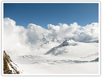
Bandarpoonch is an exquisite peak in the Western Himalayas of North India. It stands at the western edge of the High Himalayan Range where it turns northwest at an altitude of 20,720' (6316 m.) and is easily accessible with a scenic three-day hike. The Southwest ridge offers a route of moderate difficulty with little technical climbing.
The expedition can be successfully concluded in 14 days in good conditions with a strong team from the staging and acclimatization area. The most common route is from the northeast and is easily climbed in good weather and snow conditions. It is usually climbed several times a year from the north.
Getting There
The best staging and acclimatization area is the hill resort of Mussoorie (7,000') 6 hours by taxi from Delhi. From Mussoorie it is about a 5 hour taxi ride to the trailhead at Sangam Chatti (4500'). It takes you through the town of Uttarkashi (3800') 15 km from there, the last "civilization", where you can cash foreign exchange, buy fruits and vegetables and find clean sheets.
The trail begins after crossing a wide footbridge and climbs to the village of Agora 2 hours away where 'furnished' rooms are available, and Bevara (7500') almost an hour further away where in addition to bare rooms good campsites are available. Most people stop here for the night. The next day is a 7 hour hike to Dodital Lake (10,000) where good campsites and a few rooms in a forest rest house are available with prior arrangements. Well acclimatized groups may move over the 13,000' Darwa Pass the next day and camp in the Hanuman Ganga River valley at 11,500'. Firewood is available at this stage and can still be used at current rates of traffic, but should be used frugally. The next day will put climbers near the base of the mountain and base camp.
Red Tape
A trail fee of about $1.00 is to be paid at Dodital Lake for upkeep of the trail to the caretaker there. Camping fees are about 2 dollars at Dodital. Summit fees have recently been raised heavily to $2,400 for foreigners for a group of up to 12.
This area is a national preserve and no hunting or harvesting of plants is permitted though the indigenous population has free access to use what they need. In July and August some poaching of medicinal plants takes place.
When to Climb
The mountain is usually climbed in May or June when most of the snow storms have passed. However April has the advantage of snow covering approach difficulties, and fewer crowds at Dodital Lake which has become popular of late. Spring flowers are also blooming in abundance and animals are more visible. The plains of India are also less hot.
There is a risk of a spring snowstorm in April when a foot or two is not unusual. The post monsoon season in Sept., Oct. has the least snow but early season storms are a danger in late Oct. A winter climb should only be attempted with snowshoes.
Route Information
The southwest route that I have taken is up the left bank of the Hanuman Ganga River Valley through the Bugyal (alpine meadow) to the head of the valley called Beeaan. Climb the hills in a gully to the right at the end of the Bugyal and climb to a plateau known as Deodamni. Next descend one of the less steep gullies which meet the fork in the Hanuman Ganga and follow the main channel (to the right) which leads to the source of the Hanuman Ganga at the bottom of the face. This is filled with large boulders. Progress is aided by snow cover (like in mid-April).
As you approach the face you will see a prominent gully in the massif flanked on the left by a large buttress. Follow the gully and gain the top of the buttress to the left where a good campsite is available. Beware this gully is an avalanche chute